Abstract
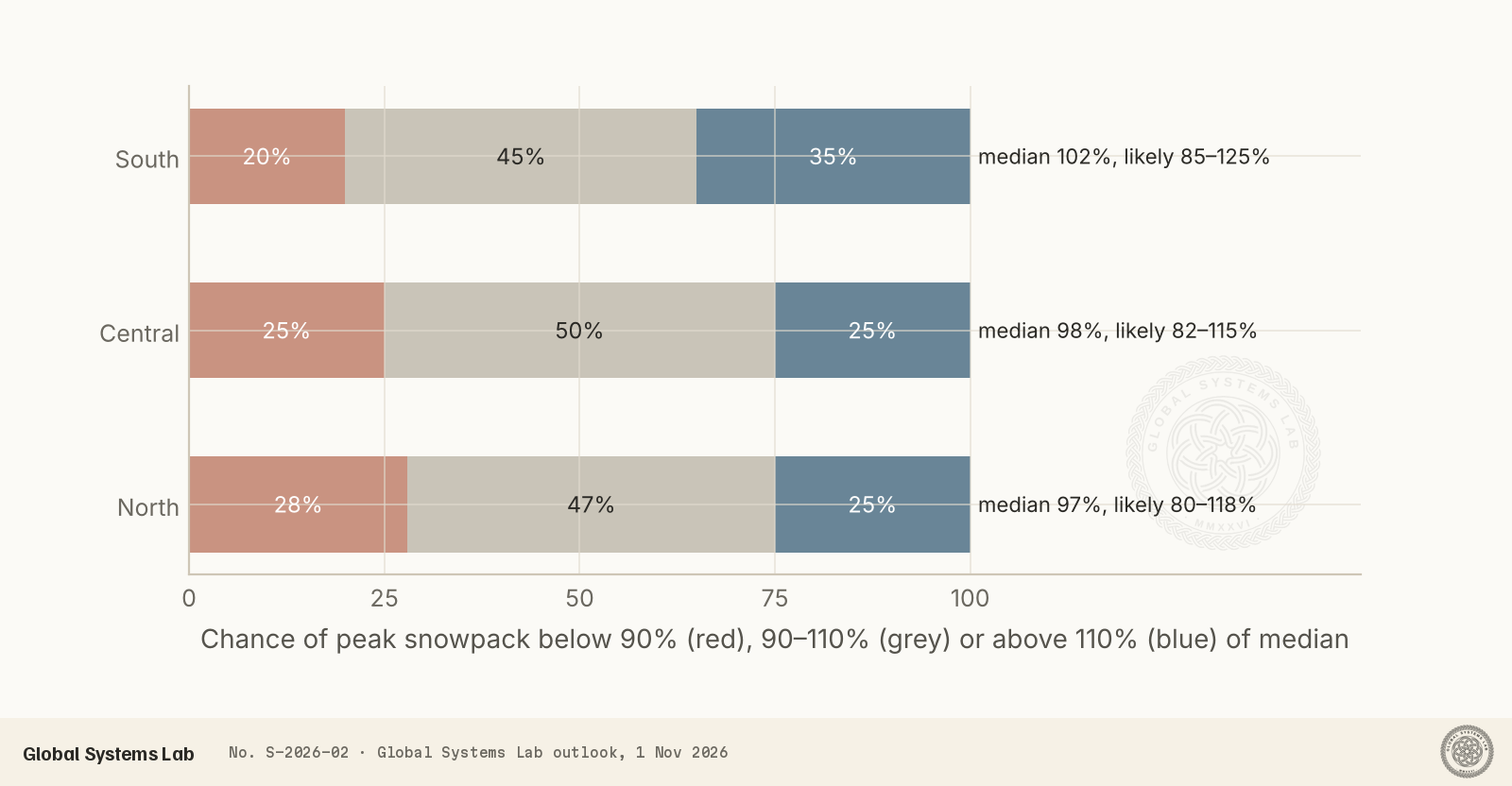
This special report is a full-winter outlook for snow in Colorado’s mountains, from this week’s storm to the spring peak of the snowpack in March and April 2027. It combines National Weather Service (NWS) forecasts, NOAA’s seasonal outlooks and an analysis of 44 winters of snowpack at 17 long-record SNOTEL sites. Colorado begins the season from a deep hole: last winter’s snowpack was the lowest on record across much of the state. October brought a lopsided start, with the San Juans running at several times their normal early-season snowpack while the northern mountains hold a fraction of theirs. A strong-to-very-strong El Niño is now almost certain to last through the winter. In the six strong El Niño winters since 1982, peak snowpack in every region came out close to normal: never a disaster, and only once a boom. On that basis, and allowing for the El Niño storm track and a warming trend, we expect peak snowpack near 102% of median in the southern mountains, 98% in the central mountains and 97% in the north. A near-normal winter is the most likely outcome everywhere, but it would not refill the state’s reservoirs after the drought.
Key findings
- The season starts lopsided. On 1 November the southern SNOTEL sites held 2 to 6 times their normal snow for the date after October’s storms, while northern sites held only 20–40%.
- This week’s storm (1–5 November) favours the same pattern: NWS warnings call for 12–18 inches above 10,000 ft in the San Juans and 5–10 inches in the central mountains, with a few inches along the northern Divide.
- In the six strong El Niño winters since 1982, peak snowpack ranged only from 81% to 112% of median in the central mountains, against 62–159% across all winters. Strong El Niño winters have tended to be near normal, not big.
- Our outlook for peak snowpack in spring 2027: southern mountains 102% of median (likely 85–125%), central 98% (82–115%), northern 97% (80–118%). The chance of another winter as poor as 2025–26 is small, under 5%.
- Expect a strong start in November, a likely lull in December and January, and the best chance of big storms in March, with the southern mountains favoured throughout.
Introduction
Colorado’s mountain snowpack is the state’s largest reservoir. Roughly three-quarters of its streamflow starts as snow, and the snow that has fallen by early April largely decides the summer’s water supply, as well as the ski season, wildfire risk and river flows for four other states downstream.
Last winter was a failure. Record warmth and too little snow left the statewide snowpack at 56% of median on 1 January 2026, with more than a third of long-record sites at record lows. By June it had almost entirely melted, at 14% of median, and the state enters this winter with depleted reservoirs and a water deficit that even a big season cannot erase.
This special report is our forecast for the winter ahead. It covers the full season: where the snowpack stands now, what this week’s storm will bring, how the winter is likely to unfold month by month, and how much snow the mountains are likely to hold at their spring peak. It draws on National Weather Service forecasts, NOAA’s seasonal outlooks and our own analysis of 44 winters of measurements from the NRCS SNOTEL network.
Data and approach
We used daily snow water equivalent (SWE), the depth of water the snowpack would yield if melted, from 17 automated SNOTEL sites with records going back to the early 1980s. We grouped them into three regions:
- Southern mountains: Wolf Creek Summit, Upper San Juan, Red Mountain Pass, Lizard Head Pass and Beartown, in the San Juan Mountains.
- Central mountains: Schofield Pass, Park Cone, Porphyry Creek, Independence Pass, Copper Mountain, Vail Mountain and Mesa Lakes, from the Elk Range and Sawatch to the Gore Range and Grand Mesa.
- Northern mountains: Berthoud Summit, Loveland Basin, Joe Wright, Tower and Rabbit Ears, along the northern Continental Divide and the Park Range.
For each winter we expressed each site’s peak SWE as a percent of its 1991–2020 median peak, then took the median across the sites in each region. We classed each winter by the state of the El Niño–Southern Oscillation (ENSO) using NOAA’s Oceanic Niño Index. The near-term forecast uses the NWS’s gridded snowfall forecast for twelve mountain points, issued on 1 November.
The seasonal outlook combines three pieces of evidence. The main one is the historical record of strong El Niño winters. We adjusted it for NOAA’s current seasonal outlooks and for the downward trend in snowpack over the past four decades. The probabilities are our judgement, informed by those numbers; they are not the output of a single model.
Where the season stands on 1 November
October gave Colorado two very different starts. Moisture from the remnants of eastern Pacific storms poured into the Four Corners in mid and late October, bringing record flooding on the San Juan River and heavy snow in the high San Juans. By 26 October, the Upper Rio Grande and the south-western basins held more than six times their normal snowpack for the date, while the South Platte and Yampa basins held less than half.
The SNOTEL sites tell the same story on 1 November. In the south, every site is far ahead of normal for the date: Wolf Creek Summit has nearly 5 inches of SWE, almost twice its median, and Beartown has about six times its median. In the north, every site is far behind. Loveland Basin, Joe Wright and Tower hold between a fifth and a third of their usual early-November snow, and the central mountains sit in between. Early-season numbers like these swing wildly, because the normals are tiny, and they say little about the final outcome. They do mean the south starts with a base, and the north does not.
This week: the first major storm of November
A strong Pacific storm is crossing the Great Basin today and will move over Colorado from Sunday through Tuesday. As in October, it favours the south and west. The NWS in Grand Junction has a winter storm warning for the San Juan Mountains above 10,000 feet until noon on Monday, with 12 to 18 inches expected and gusts to 45 mph. A winter weather advisory covers the Grand Mesa, the West Elks, the Sawatch and the Flat Tops, with 5 to 10 inches. Snow levels will start above 10,000 to 11,000 feet and fall to around 8,000 feet by Monday morning. For the northern mountains the Denver/Boulder office gives a better than 70% chance of snow above 8,500 feet, with a few inches expected.
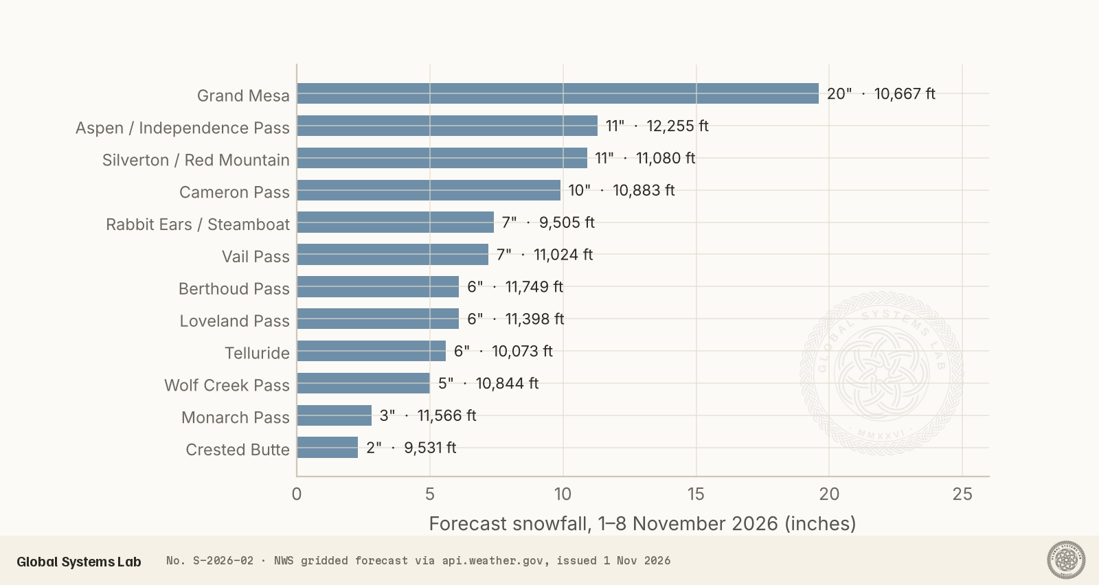
The point forecasts show the shape of the storm: about 20 inches on the Grand Mesa, around 10 to 11 inches near Independence Pass, Red Mountain Pass and Cameron Pass, and 5 to 7 inches across Vail, Loveland and Berthoud passes. Rain below the snow line raises the risk of more flooding in south-western Colorado, where rivers are still high. A second, weaker system is likely around 6 to 9 November and could bring the first accumulating snow of the season to the foothills and the I-25 corridor.
The big driver: a strong El Niño
The dominant influence on this winter is in the tropical Pacific. NOAA declared El Niño conditions in June, and by October the Climate Prediction Center rated a strong-to-very-strong event as likely through January to March 2027, with odds above 83%. El Niño shifts the Pacific jet stream south, steering more storms into California, the Southwest and the southern Rockies, and fewer into the northern Rockies.
Colorado sits on the boundary between the wet south and the dry north, which is why its El Niño winters are so varied. NOAA’s 15 October outlook for December to February leans wet for the whole state, with a 33–40% chance of above-normal precipitation in the western and central mountains and 40–50% on the eastern plains, and gives no clear signal for temperature. An outlook for precipitation is not a snowfall forecast, though. Snow depends on temperature too, and a mild storm can bring rain at elevations that would normally get snow.
What strong El Niño winters have done before
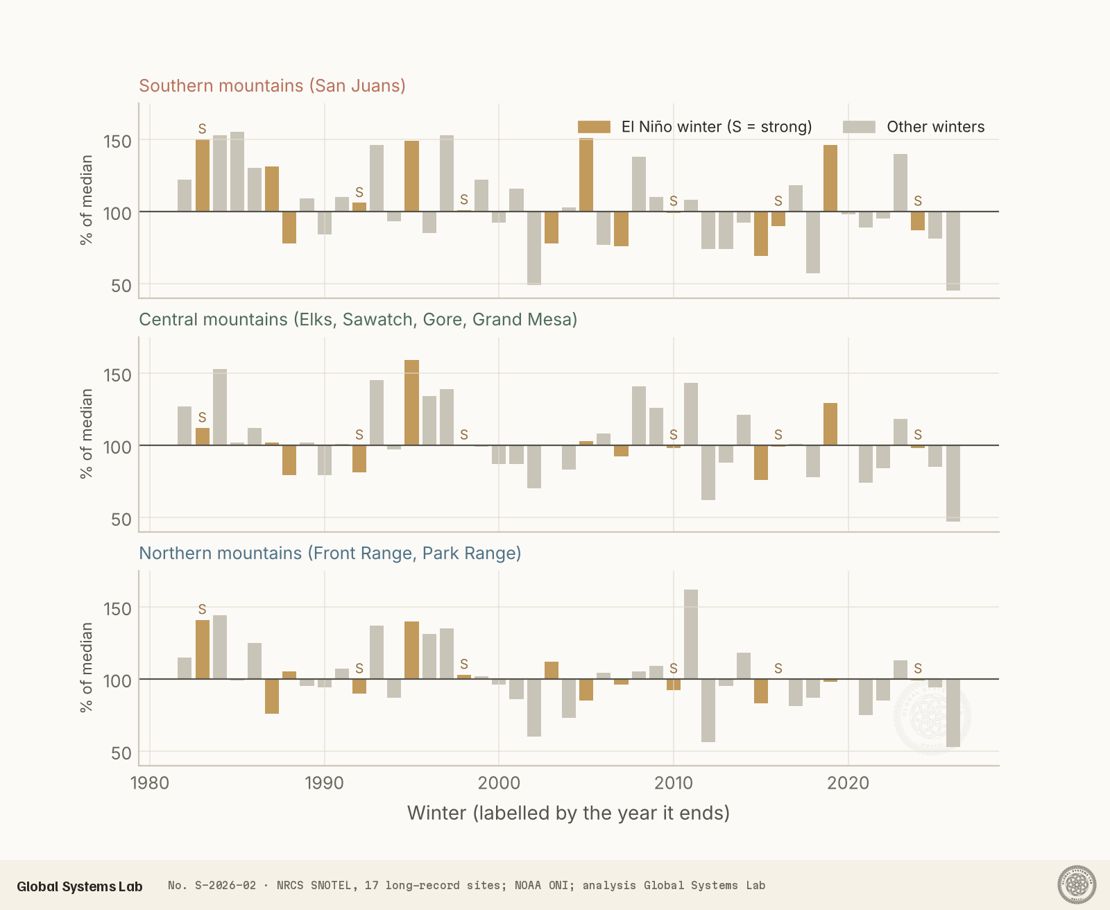
Six winters since 1982 had a strong or very strong El Niño: 1982–83, 1991–92, 1997–98, 2009–10, 2015–16 and 2023–24. Their snowpack history holds the most useful lesson for this winter. They were not especially snowy. In the southern mountains their median peak was 100% of normal, and in the central and northern mountains 98% and 100%. What stands out is how narrow the range was. In the central mountains, peak snowpack across those six winters ran from 81% to 112% of median, against 62% to 159% across all winters. Only 1982–83 was a big year, and none was a disaster. The northern mountains never fell below 90% in a strong El Niño winter.
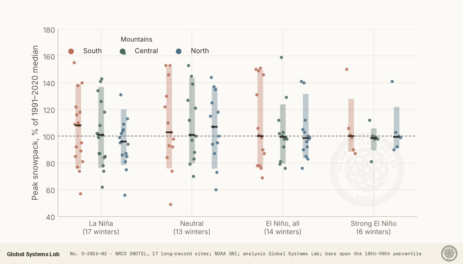
Weaker El Niño winters were more varied, including both the huge winter of 2004–05 in the San Juans and the poor winter of 2014–15. La Niña and neutral winters produced both the biggest and the smallest years in the record. Six winters are a small sample, and an independent analysis by the Colorado Climate Center finds no consistent statewide El Niño signal. Still, the evidence points the same way: a strong El Niño loads the dice towards an ordinary winter in Colorado.
There is a second, less welcome signal. Across all three regions, peak snowpack has declined over the record: by about 9 percentage points per decade in the south and 5 to 6 in the central and northern mountains, compared with the 1991–2020 median. The most recent strong El Niño winters, 2015–16 and 2023–24, came in slightly below normal in the south. Warmer winters also bring the snowpack peak earlier, now often in mid-March rather than early April.
Our outlook for the winter
Taking all of this together, our outlook for peak snowpack in spring 2027 is:
| Region | Central estimate | Likely range | Below 90% | 90–110% | Above 110% |
|---|---|---|---|---|---|
| Southern mountains | 102% | 85–125% | 20% | 45% | 35% |
| Central mountains | 98% | 82–115% | 25% | 50% | 25% |
| Northern mountains | 97% | 80–118% | 28% | 47% | 25% |
We tilt the south towards above normal because it is favoured by the El Niño storm track and NOAA’s outlook, and because it already has an early base. The northern mountains get our weakest odds. They sit closest to El Niño’s dry side, they start nearly bare, and their record in moderate El Niño winters is mixed. In every region, a near-normal winter is the single most likely outcome. The chance of another winter as poor as 2025–26, when peak snowpack fell below 55% of median in all three regions, is small: no El Niño winter since 1982 fell below 69% in any region, and we put it under 5%.
Month by month
Past El Niño winters suggest a recognisable rhythm, and this season’s start fits it.
- November should be active. Past El Niño Novembers have usually added more snow than normal, and this one opens with two storms in its first ten days. Expect the south and west to keep their lead. Breckenridge plans to open on 6 November and Vail on 13 November, with more resorts to follow later in the month.
- December and January carry the greatest risk of a lull. Snowpack gains in past El Niño Decembers were mostly below normal, typically 65–80% of the usual amount, and Januarys were close to normal. A dry spell around the holidays would not be a sign that the winter has failed.
- February has been close to normal in El Niño winters.
- March and April offer the best chance of big storms. In past El Niño winters, March was the strongest month, often 120–200% of normal snowpack gain, with deep, wet storms from the south-west and upslope snow on the Front Range. Most of the difference between an average and a good winter is likely to be decided in March.
What it means
A near-normal snowpack would be a large improvement on last winter, enough for a full ski season and a normal spring runoff in most basins. It would not end the water shortage. After a record-low runoff year, dry soils will absorb much of the spring melt before it reaches rivers, and reservoirs need more than one average year to recover. Water managers should plan for a recovery, not a reset.
The early season brings its own hazards. Snow falling on bare ground and then on old, weak early layers often creates a poor foundation for the winter’s snowpack, raising avalanche risk once the big storms arrive. Anyone heading into the backcountry should follow the Colorado Avalanche Information Center.
Uncertainty and limitations
Seasonal snow forecasting has limited skill. El Niño tilts the odds but does not decide a winter, and the timing of a handful of big storms often matters more than the season’s average pattern. Our sample of strong El Niño winters is only six. SNOTEL sites sit at mid to upper elevations in sheltered forest clearings; they represent the regions well, but not every slope or valley. The near-term figures are a single forecast run and will change. We will revisit this outlook after NOAA’s next seasonal update in mid-November and again at the start of each month.
Conclusions
Colorado’s mountains begin winter 2026–27 from the bottom of a record drought, with a lopsided start: deep early snow in the San Juans and almost nothing along the northern Divide. A strong El Niño now dominates the season. History suggests it will steer the state towards a near-normal winter, with the south favoured over the north. Our best estimate is a spring peak close to 100% of median everywhere: a little above in the San Juans and a little below in the north. The months to watch are November, which has started well, and March, which will probably decide the season. For Colorado’s water supply, an ordinary winter would be welcome, but it would only be a start.
References
- USDA Natural Resources Conservation Service (2026). SNOTEL daily snow water equivalent, Colorado, water years 1981–2027. Air and Water Database REST API, accessed 1 November 2026. https://wcc.sc.egov.usda.gov/awdbRestApi/
- USDA NRCS Colorado (2026). Record low snowpack observed across much of Colorado heading into 2026 (12 January 2026); Colorado Water Supply Outlook Report, 1 June 2026. https://www.nrcs.usda.gov/state-offices/colorado/news/record-low-snowpack-observed-across-much-of-colorado-heading-into-2026
- National Weather Service (2026). Gridded forecast data, Colorado mountain points, issued 1 November 2026; Area Forecast Discussion, Denver/Boulder, 1 November 2026; Winter Storm Warning, San Juan Mountains, Grand Junction. https://api.weather.gov/
- NOAA Climate Prediction Center (2026). ENSO Diagnostic Discussion, 8 October 2026, and seasonal outlooks issued 15 October 2026. https://www.cpc.ncep.noaa.gov/products/predictions/90day/
- NOAA Climate Prediction Center. Oceanic Niño Index (ONI), 1950–present. https://origin.cpc.ncep.noaa.gov/products/analysis_monitoring/ensostuff/ONI_v5.php
- Collentine, S. (2026). 2026–2027 Colorado winter forecast. OpenSnow, 15 September 2026. https://opensnow.com/news/post/2026-2027-colorado-winter-forecast
- SnowBrains (2026). NOAA winter outlook favors a wet winter for California, the Southwest and Colorado, 15 October 2026. https://snowbrains.com/noaa-winter-outlook-2026-27/
- Denver Gazette (2026). 24 inches of snow lands in Colorado: one region at 666% of snowpack norm, 26 October 2026. https://www.denvergazette.com/2026/10/26/24-of-snow-lands-in-colorado-one-region-at-666-of-snowpack-norm/
- Denver Gazette (2026). Two upcoming waves of snow could bring 29 inches of snow to part of Colorado, 27 October 2026. https://www.denvergazette.com/2026/10/27/two-upcoming-waves-of-snow-could-bring-29-of-snow-to-part-of-colorado/
- KKCO 11 News (2026). Heavy rain and mountain snow likely starting Sunday, 31 October 2026. https://www.kkco11news.com/2026/11/01/heavy-rain-mountain-snow-likely-starting-sunday/
- Colorado Public Radio (2026). Here’s what to know about Colorado’s winter this year, 17 September 2026. https://www.cpr.org/2026/09/17/colorado-2026-winter-snow-forecast/
- Associated Press (2026). More rain is expected after bad flooding in the Four Corners region led to rescues and evacuations, 24 October 2026. https://www.news4jax.com/news/national/2026/10/24/more-rain-is-expected-after-bad-flooding-in-the-four-corners-region-led-to-rescues-and-evacuations/
Data availability
Two data files are available below. The first gives peak and 1 April snow water equivalent for each winter from 1982 to 2026, as a percent of the 1991–2020 median, for the southern, central and northern site groups, with each winter’s ENSO phase. The second (data.json) adds the 1 November status of each of the 17 SNOTEL sites and the NWS point snowfall forecasts behind the figures. SNOTEL data are provisional and may be revised by the NRCS. We will update this outlook as the winter unfolds.
Cite this
Global Systems Lab (2026). Colorado mountain snow, winter 2026–27: our outlook from first flakes to spring peak. Global Systems Lab Transmission S-2026-02. https://globalsystemslab.com/transmission/colorado-snow-outlook-2026-27
BibTeX
@techreport{lab2026colorado,
  author = {Global Systems Lab},
  title = {Colorado mountain snow, winter 2026–27: our outlook from first flakes to spring peak},
  institution = {Global Systems Lab},
  number = {S-2026-02},
  year = {2026},
  month = {nov},
  url = {https://globalsystemslab.com/transmission/colorado-snow-outlook-2026-27}
}