Abstract
The 2026 eastern Pacific hurricane season broke the record for accumulated cyclone energy on 11 October, with three Category 5 hurricanes and the second most intense Pacific hurricane ever measured. This special report looks back at the tropical cyclones that struck Mexico between June and October. It draws on US National Hurricane Center (NHC) advisories, statements from Mexico’s federal and state civil protection agencies, and news reporting. Five systems brought deadly impacts. Only one hurricane, Polo, actually made landfall: as a Category 2 in Baja California Sur on 29 September, and then as a Category 1 in Sonora. Two powerful hurricanes, Simon and Trudy, stayed just offshore of Jalisco and Colima. The deadliest systems were Polo and the remnants of Rachel, which each killed eight people. Rachel came ashore well below hurricane strength, and most of Polo’s deaths came from rain, some of it hundreds of kilometres from the coast. Across the season, provisional official counts give at least 26 deaths in Mexico, nearly all from flooding, landslides and swollen streams, not wind.
Key findings
- Polo was the only hurricane to make landfall in Mexico in 2026: a Category 2 near Las Barrancas, Baja California Sur, on 29 September, and a Category 1 near Guaymas, Sonora, hours later. A week earlier at sea it had peaked at 180 mph and 892 mbar, second only to Patricia (2015) in the Pacific.
- Simon (peak 155 mph) and Trudy (peak 120 mph) both tracked parallel to the Jalisco–Colima coast in October without making landfall, sparing the coast their strongest winds but not their rain or surf.
- At least 26 people died in Mexico, by provisional official counts. Rachel’s remnants killed 8 in Ensenada and Polo killed 8 in Jalisco, Chihuahua and Sonora, with 5 still missing between them.
- Water, not wind, did the killing: houses swept away by rivers, collapsed walls, people caught crossing flooded streams. Several deaths came days before landfall or far inland.
- The eastern Pacific passed the 2018 record for accumulated cyclone energy on 11 October and reached about 331 units by 15 October, with three Category 5 hurricanes.
Introduction
By almost any measure, 2026 was an extraordinary year for hurricanes in the eastern Pacific. A strong El Niño warmed the ocean off Mexico and Central America, and storm after storm drew on that heat. By mid-October the basin had produced 22 named storms, 12 hurricanes, 9 major hurricanes and a record-tying three Category 5s. On 11 October its accumulated cyclone energy, a combined measure of how strong storms were and how long they lasted, passed the full-season record set in 2018. Meanwhile the Atlantic, held back by the same El Niño, did not produce its first hurricane until 8 October.
For Mexico, the question is not how active the ocean was but what reached the coast. This special report looks back at the five tropical cyclones that caused deaths in Mexico between June and October 2026. Where did they come ashore, how strong were they when they did, and what did the damage look like? Unlike our regular reports, it is not built on the lab’s own instruments. It draws on open sources: hurricane centre advisories, statements from Mexican authorities, and news reporting from Mexico and abroad.
Sources and approach
The storm details come from public advisories by the US National Hurricane Center (NHC), which is responsible for the eastern North Pacific. Mexico’s National Meteorological Service (SMN) issues parallel bulletins. Casualty and damage figures come from Mexico’s federal and state civil protection agencies and state governors, as reported by the Associated Press, Reuters, Xinhua and Mexican outlets including Excélsior and Mexico News Daily. We cross-checked figures across sources, used the most recent official count where they differed, and say so where they still conflict.
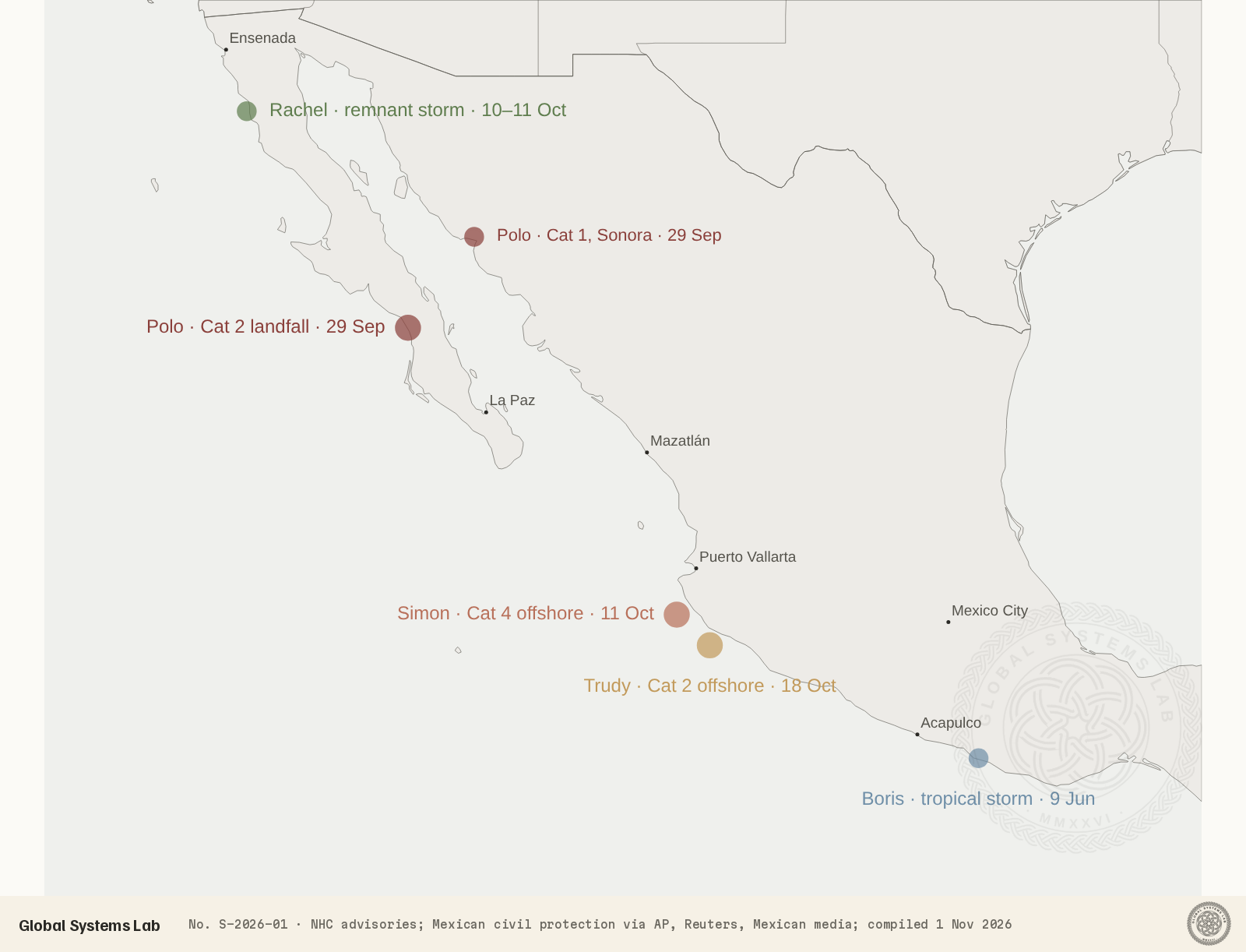
Three cautions apply. First, these are operational figures. The NHC’s final analyses, which can revise intensities and positions, usually appear months after the season ends. Second, death tolls after floods often rise for weeks as the missing are found, and figures for remote areas arrive late. Third, the positions on our map are approximate, placed from the town names in the advisories.
The season at a glance
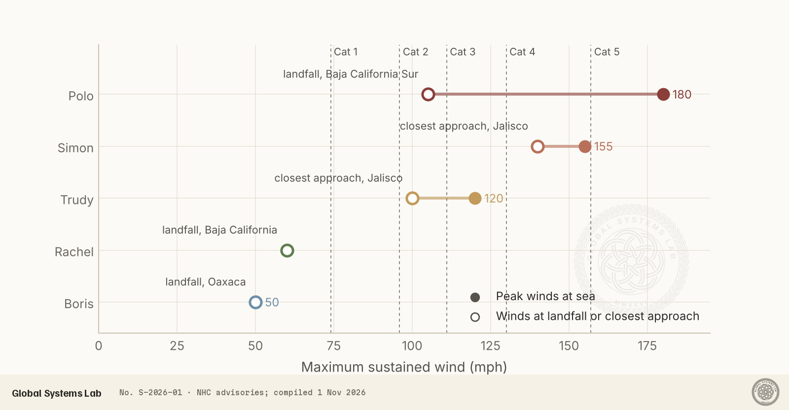
The figure above sets out the pattern of the year. The three strongest storms that threatened Mexico all peaked well offshore, then weakened before or as they reached the coast. Cooler water churned up by earlier storms, dry air flowing down from the Sierra Madre, wind shear and the rugged coastline all played a part. For the people living there, that weakening made the difference between a dangerous storm and a catastrophic one. It did not make the storms harmless. The worst losses came from rain.
Boris: an early warning in June
Tropical Storm Boris formed off south-western Mexico on 7 June and came ashore on the far south-western coast of Oaxaca on 9 June with winds of about 50 mph. Boris never became a hurricane, but its rain caused four deaths in Colima and Oaxaca and flooding as far west as Acapulco. Insured-loss specialists put damage at around US$100 million. A day later Tropical Storm Cristina, passing off Central America, brought flooding to Chiapas in which a man drowned.
Polo: the year’s only hurricane landfall
Polo was the storm of the season. It formed on 20 September south of Mexico and, within days, became one of the most intense hurricanes ever observed in the Pacific. Its winds rose by around 110 mph in 24 hours, among the fastest intensification rates on record. On 22 September it reached 180 mph with a central pressure of 892 millibars. Only Hurricane Patricia in 2015 has recorded a lower pressure in the eastern Pacific. Polo reached Category 5 three separate times, the first Pacific hurricane known to do so, and held that strength for a record 78 hours in total.
For most of that week Polo curved slowly offshore, parallel to the coast. Even at sea it was deadly. Its outer rain bands swept a house away in Talpa de Allende, in the mountains of Jalisco, killing four people, and a woman was pulled out to sea at Puerto Vallarta and is still missing.
By the time Polo turned towards the Baja California peninsula, dry air, wind shear and land had taken their toll. It made landfall near Las Barrancas, in the thinly populated Comondú municipality of Baja California Sur, late on 28 September local time as a Category 2. Few storms that strong have struck the peninsula: Polo is one of only about ten hurricanes of Category 2 or above to do so since records began in 1949. The state reported no deaths. More than 80 homes were damaged and 11 destroyed in Comondú, and about 20,000 customers lost power. Some 6,700 people who had evacuated returned home the next day.
Polo crossed the Gulf of California and came ashore again east of Guaymas, Sonora, on 29 September as a Category 1. It was here, and further inland, that it did the most damage. Sonora reported more than 8,150 damaged homes, four damaged bridges and about 400 km of damaged roads, and a man was swept away by an overflowing river. The remnants then soaked northern Mexico and the south-western United States, where flood watches covered parts of eleven states. Three more people died in Chihuahua, two of them in Ciudad Juárez. In all, Polo killed eight people in Mexico, almost all of them far from where its strongest winds came ashore.
Rachel: a weakened storm, the deadliest flooding
Rachel was a long-lived storm that spent nearly two weeks over the open Pacific, at one point as a major hurricane, before an approaching trough swung it sharply north-east. By the time it reached northern Baja California on the night of 10–11 October, it had weakened to a post-tropical storm with winds of about 60 mph. Few would have picked it as the season’s deadliest system in Mexico.
Its rain fell on steep, dry hills above Ensenada, and the streams that drain them rose in the night. Residents described a roar like breaking waves before the water came through their homes, sweeping away vehicles, cabins and animals. Eight people died in Ensenada municipality, four of them children, and five of the dead were from a single family visiting from Hermosillo. Four more people were still missing days later, and a father and son who had gone fishing from San Felipe on the Gulf of California did not return. Army helicopters lifted 32 people, 13 of them minors, from a ranch cut off by floodwaters. State authorities reported serious damage to at least 370 homes in Ensenada and 258 in San Quintín, as well as flooded warehouses, destroyed greenhouses and dead livestock, and deployed about 14,000 federal and state personnel.
Simon and Trudy: two near misses on the Jalisco coast
On the same weekend, a very different storm threatened the opposite end of the coast. Simon formed on 7 October off south-western Mexico, swung north and intensified rapidly to Category 4, peaking at about 155 mph. On 11 October its eye moved parallel to the coast just south of Cabo Corrientes, close to Puerto Vallarta, with sustained winds of about 140 mph. Hurricane warnings covered the coast from Manzanillo to Punta Mita. About 5,000 people were evacuated in Jalisco and Colima, the Navy ferried families from the boat-only villages of Yelapa and Quimixto, and more than 22,000 federal, state and municipal personnel were deployed.
Simon never made landfall. The rugged coastline and dry air flowing off the mountains weakened it, and it drifted slowly offshore for several days. Forecasts of a landfall in Sinaloa did not come true, and the storm faded at sea by 16 October. Its rain still did damage. In Guerrero, 391 mm fell in 24 hours, a wall collapse killed a man in Chilpancingo, and 65,780 customers lost power. Surf damaged the boardwalk at Cihuatlán, and a young man drowned in a flooded river in Chiapas. Five deaths have been attributed to Simon in Mexico, with losses estimated above US$10 million.
Trudy followed less than a week later. It formed on 13 October, became a major hurricane with 120 mph winds on 15 October, weakened sharply, and then restrengthened to a Category 2. On the night of 17–18 October it passed close to the coast between Manzanillo and Cabo Corrientes, much as Simon had, before veering west and dissipating over the ocean. Forecasters expected 10 to 20 cm of rain across Michoacán, Colima and Jalisco, with locally more. We found no reports of deaths from Trudy.
The Atlantic side
Mexico’s Gulf coast had a quiet year. No Atlantic storm made landfall in Mexico. Tropical Storm Arthur in June caused river flooding in northern Mexico, including at Piedras Negras, before coming ashore in Texas. In early October, the disturbance that became Hurricane Isaias, together with a cold front, brought flooding, fallen trees and power cuts to Tamaulipas and Veracruz before the storm strengthened and hit Florida.
Human toll
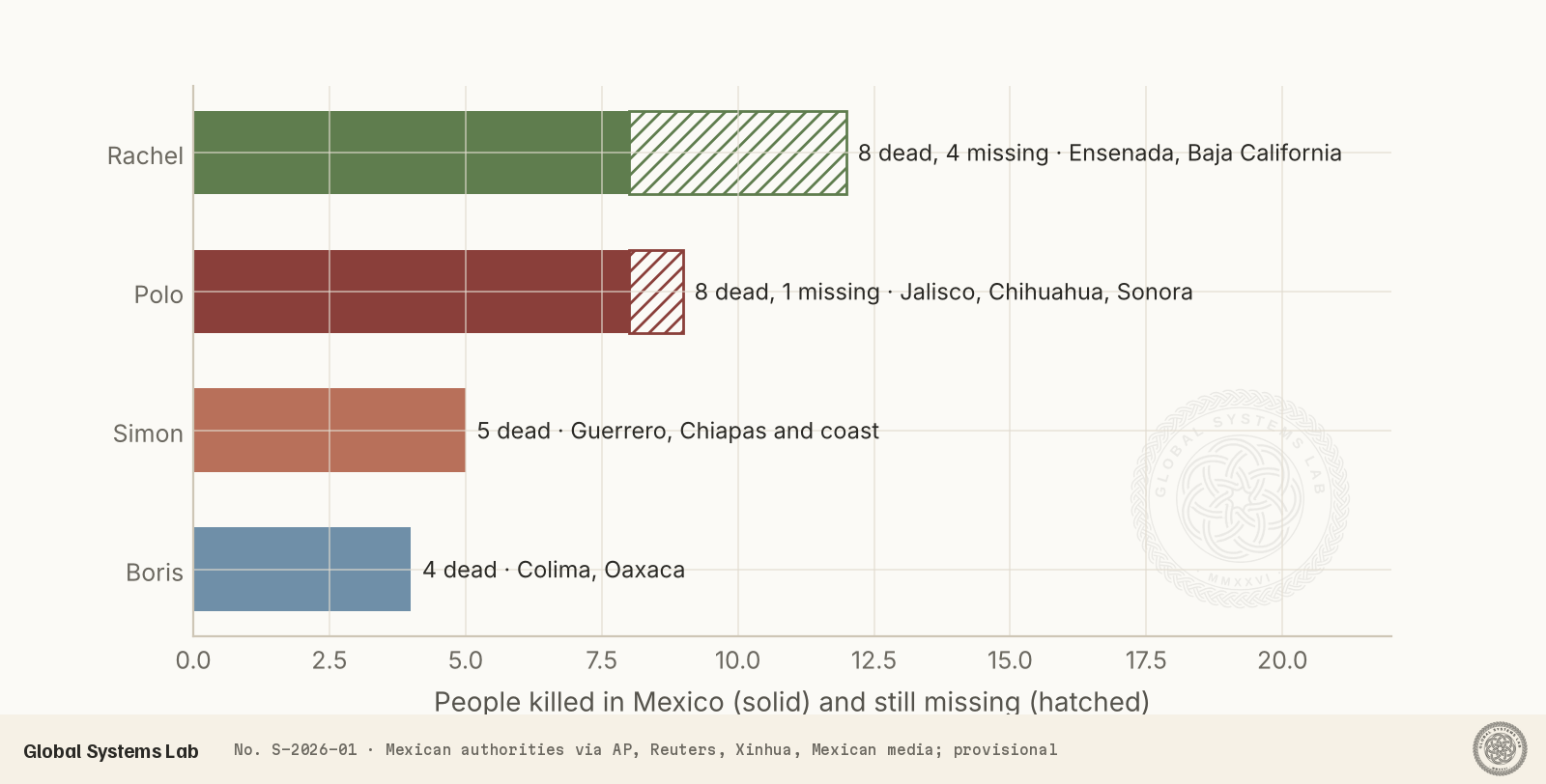
By the official counts available on 1 November, tropical cyclones killed at least 26 people in Mexico in 2026: eight from Rachel, eight from Polo, five from Simon, four from Boris and one from Cristina. At least five people are still missing. The pattern is consistent. Very few of these deaths came from wind. People died when rivers took their homes, when walls weakened by rain collapsed, when they crossed swollen streams, or when they were caught in heavy surf. Several died days before a storm made landfall, or hundreds of kilometres inland. Rachel, the weakest storm to reach land, was the deadliest.
The lesson has been seen before in Mexico. Storms that stall offshore, or arrive weakened, can still deliver extreme rain to steep terrain, and a storm’s wind category is a poor guide to its flood risk. Mexico’s evacuation and preparation work in 2026 was extensive: tens of thousands of responders, hundreds of shelters and early school closures. It probably prevented many more deaths from Polo and Simon. Flash flooding in small, steep catchments like Ensenada’s remains hard to forecast and to warn for in time.
Uncertainty and limitations
All figures here are provisional. Intensities come from operational advisories and may be revised in the NHC’s final reports. Death tolls are the latest official numbers we could find, and some deaths, such as a cliff diver who drowned at Mazatlán in heavy surf during Simon, have not been officially attributed to a storm. Damage estimates are early industry figures. Our map positions are approximate. The season is not over: the eastern Pacific season runs until 30 November, and in late October the remnants of Tropical Storm Vance brought heavy rain towards Sinaloa and the tip of Baja California.
Conclusions
The 2026 eastern Pacific hurricane season will be remembered for records set at sea: the most energetic season on record, three Category 5s, and Polo’s 892-millibar peak. For Mexico, the story is different. Only one hurricane made landfall, and it did so weakened and in a sparsely populated place. Two more major hurricanes brushed the Jalisco coast and turned away. Mexico was, in that sense, lucky.
It was not spared. At least 26 people died, nearly all of them in floods, and the deadliest storm was a weakened remnant that few would have called a threat. Record-warm oceans make storms like Polo more likely, and attribution analysis suggests the water Polo crossed was about 1.5 °C warmer than it would have been without human-caused warming. As that continues, Mexico’s next near miss may not miss. We will update this report when the NHC publishes its final storm reports.
References
- National Hurricane Center (2026). Public advisories and forecast discussions for Tropical Storm Boris and Hurricanes Polo, Rachel, Simon and Trudy, eastern North Pacific. NOAA/National Weather Service, Miami. https://www.nhc.noaa.gov/
- Associated Press (2026, 13 October). Death toll rises to 6 as Hurricane Simon and Rachel remnants unleash floods in Mexico. https://www.itv.com/news/2026-10-13/hurricane-remnants-unleash-deadly-floods-in-mexico-killing-at-least-6
- Xinhua (2026, 15 October). Death toll from Tropical Storm Rachel rises to 8 in northwestern Mexico. https://www.thestar.com.my/news/world/2026/10/16/death-toll-from-tropical-storm-rachel-rises-to-8-in-northwestern-mexico
- Excélsior (2026). Ascienden a 8 los muertos por ‘Rachel’ en Baja California; hay 4 menores. https://www.excelsior.com.mx/nacional/rachel-muertos-baja-california
- ABC News (2026, 29 September). Hurricane Polo makes 2nd landfall in Mexico as Category 1 storm. https://abcnews.com/International/hurricane-polo-makes-baja-landfall-headed-2nd-mexico/story?id=136848159
- Mexico News Daily (2026). Hurricane Polo hits the Sonora coast after making landfall and crossing the Baja Peninsula. https://mexiconewsdaily.com/news/hurricane-polo-hits-sonora-coast-after-making-landfall-crossing-baja-peninsula/
- Mexico Solidarity Media (2026). Hurricane ‘Polo’ leaves no fatalities in Baja California Sur; to hit Guaymas, Sonora. https://mexicosolidarity.com/hurricane-polo-guaymas-sonora/
- Henson, B. and Masters, J. (2026). After two landfalls in Mexico, Hurricane Polo’s rainmaking journey has just begun. Yale Climate Connections. https://yaleclimateconnections.org/2026/09/after-two-landfalls-in-mexico-hurricane-polos-rainmaking-journey-has-just-begun/
- Masters, J. (2026). Hurricane Trudy drenching Mexico; Guam braces for another typhoon. Yale Climate Connections. https://yaleclimateconnections.org/2026/10/hurricane-trudy-drenching-mexico-guam-braces-for-another-typhoon/
- Associated Press (2026, 11 October). Hurricane Simon hits Mexico’s Pacific coast with damaging winds and rain. PBS NewsHour. https://www.pbs.org/newshour/world/hurricane-simon-hits-mexicos-pacific-coast
- Reuters (2026, 12 October). Hurricane Simon crawls along Mexico’s Pacific coast, bringing floods and evacuations. https://www.usnews.com/news/world/articles/2026-10-12/hurricane-simon-crawls-along-mexicos-pacific-coast-bringing-floods-and-evacuations
- Reuters (2026, 17 October). Hurricane Trudy gains strength near Mexico’s coast, but is expected to weaken by Sunday. https://www.usnews.com/news/world/articles/2026-10-17/hurricane-trudy-threatens-western-mexico-with-heavy-rain-coastal-flooding
- NASA Earth Observatory (2026, 14 October). Hurricane Simon lurks off the Mexican coast. https://science.nasa.gov/earth/earth-observatory/hurricane-simon-lurks-off-the-mexican-coast/
- Swellnet (2026, 14 October). Eastern Pacific breaks hurricane record. https://www.swellnet.com/news/swellnet-dispatch/2026/10/14/eastern-pacific-breaks-hurricane-record
- Wikipedia contributors (2026). 2026 Pacific hurricane season; Hurricane Polo; Hurricane Simon. Accessed 1 November 2026. Used for cross-checking only. https://en.wikipedia.org/wiki/2026_Pacific_hurricane_season
Data availability
A table of the events shown in the figures is available below as a CSV file: storm, dates, peak wind, wind at landfall or closest approach, approximate position, and provisional death and missing counts in Mexico. Positions are approximate, taken from the place names in NHC advisories rather than from final best-track data, which the NHC normally publishes in its tropical cyclone reports in the months after a season ends. Casualty figures are the latest official counts reported by 1 November 2026 and may change.
Cite this
Global Systems Lab (2026). Mexico's 2026 hurricane season: a record year at sea, and the storms that reached land. Global Systems Lab Transmission S-2026-01. https://globalsystemslab.com/transmission/mexico-hurricanes-2026
BibTeX
@techreport{lab2026mexico,
  author = {Global Systems Lab},
  title = {Mexico's 2026 hurricane season: a record year at sea, and the storms that reached land},
  institution = {Global Systems Lab},
  number = {S-2026-01},
  year = {2026},
  month = {nov},
  url = {https://globalsystemslab.com/transmission/mexico-hurricanes-2026}
}