The desert Southwest is having a very un-desert day. A long, narrow plume of subtropical moisture, the kind of feature meteorologists call an atmospheric river, has swung north-east out of the Pacific near Baja California and is pouring rain across Arizona, southern and central Utah, western New Mexico and south-western Colorado. The National Weather Service office in Phoenix describes it as the first atmospheric river of the season and one of the strongest to reach the region in the past decade, measured by how much water vapour it carries. By midday in Arizona, 88 weather alerts were in force across the five states, 72 of them for flooding.
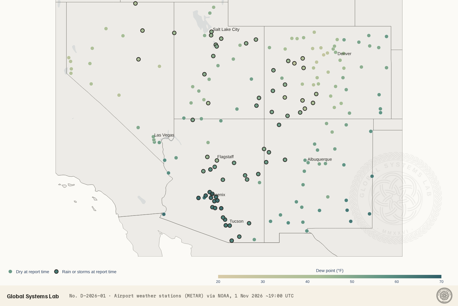
This brief reads the event through the lab’s NOAA Weather Map: the latest report from each of the region’s 201 airport weather stations, the Weather Service’s forecasts for seven cities, and the warnings in force. The station readings were taken at about 19:00 UTC, which is noon in Arizona and 1 pm in New Mexico, Utah and Colorado.
Where it is raining now
At report time, 71 of the 201 stations were reporting rain, showers or thunder. The wet area follows the plume’s path from south-west to north-east: 34 of Arizona’s 45 stations were reporting rain, along with 13 of 32 in Utah and 15 of 67 in Colorado, mostly on the Western Slope. Nevada, which sits west of the plume, was largely dry (4 of 22 stations), as was most of New Mexico at midday (5 of 35), though the heaviest rain there is expected to arrive this afternoon and tonight. Thunder was being reported at Nogales on the Mexican border, at Nellis Air Force Base near Las Vegas and on the plains of eastern New Mexico.
The clearest sign of how unusual the air is comes from the dew point, the temperature at which the air would become saturated. In Phoenix the dew point was 66 °F, with the air temperature just 68 °F under light rain. Dew points in the mid-60s are typical of the summer monsoon in July and August, not of November, when the desert air is normally dry. Tucson stood at 65 °F with a dew point of 62 °F, also under light rain, and much of central and southern Arizona showed dew points in the low to mid 60s. By contrast, Las Vegas, on the dry western edge of the plume, had a dew point of 49 °F and wind gusting to 28 mph.
Further north the same moisture was falling as cooler rain. Salt Lake City reported 50 °F and light rain, Grand Junction 52 °F and rain, and Flagstaff, at 7,000 feet, 48 °F with rain, mist and gusts to 31 mph. Denver, still ahead of the system, was dry at 63 °F with a dew point of just 44 °F.
What forecasters expect
The Weather Service’s discussions, written by its forecasters each morning, lay out the shape of the event.
- Arizona. The Phoenix office expects widespread showers and isolated storms through today, with a Flood Watch for much of central and eastern Arizona through tonight. Some storms east of the Colorado River could turn severe, mainly with damaging winds. Phoenix could pick up a further half to three-quarters of an inch of rain. Tucson reports that the event had already over-delivered by this morning, with a quarter of an inch to an inch of rain at most sites in the previous 24 hours and 2 to 3 inches on Mount Lemmon and Mount Graham. A Flood Watch covers all of south-east Arizona until 5 am on Monday.
- Utah. The Salt Lake City office places parts of southern Utah under a Moderate Risk of excessive rainfall, level 3 of 4, with a Flood Watch for much of southern and east-central Utah into this evening. A cold front near the Nevada border is turning the higher-elevation rain to snow: up to a foot above 9,000 feet, 3 to 6 inches down to about 7,000 feet, and locally 18 to 24 inches in the upper Cottonwood canyons and the western Uintas.
- New Mexico. The Albuquerque office expects the heavier rain to move into western New Mexico today and last into Monday morning. Soils are already saturated, so there is a moderate to high chance of river flooding in the north and west. Severe thunderstorms are possible across central and eastern New Mexico this afternoon and tonight, with hail, damaging winds and a risk of tornadoes, and a few inches of snow are expected on the northern mountains above 9,000 feet.
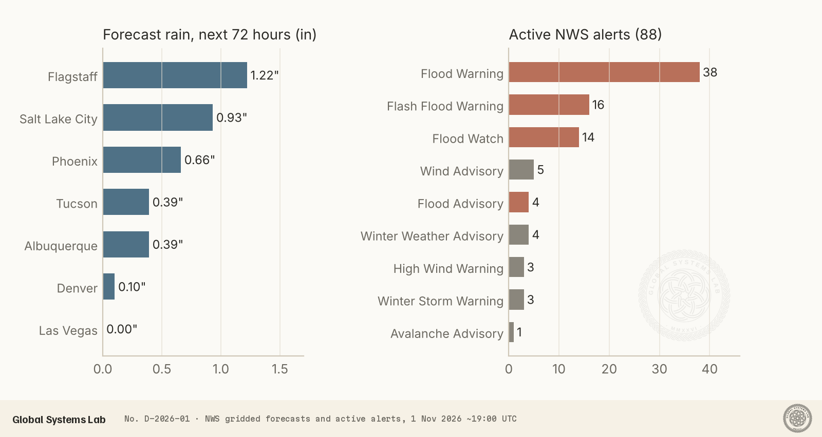
The Weather Service’s gridded forecasts give a sense of how much more rain is coming over the next three days: about 1.2 inches at Flagstaff, 0.9 inches at Salt Lake City, 0.7 inches at Phoenix, 0.4 inches at Tucson and Albuquerque, a tenth of an inch at Denver, and none at Las Vegas.
The warnings in force
Of the 88 active alerts touching the region at midday, 38 were Flood Warnings and 16 Flash Flood Warnings, among them warnings for Arizona’s Maricopa, Pinal, Gila, Yavapai, Coconino, Pima, Santa Cruz, Cochise and Graham counties. Fourteen Flood Watches and four Flood Advisories cover wider areas, including San Juan and Catron counties in New Mexico and Mohave County in Arizona. Away from the rain, the same storm system is bringing wind and snow: three High Wind Warnings for the mountains of south-central and south-eastern New Mexico, five Wind Advisories, three Winter Storm Warnings for the San Juan Mountains of Colorado and Nevada’s Ruby Mountains, four Winter Weather Advisories for Colorado’s high country, and an avalanche advisory for the West Elk, Sawatch and San Juan ranges. The strongest gust in the station network at report time was 55 mph at Wolf Creek Pass, Colorado, with gusts of 41 to 44 mph at Raton and Melrose in New Mexico, Springfield in Colorado and the Grand Canyon airport.
Flash flooding in the desert is dangerous because it is sudden. Dry washes and dips in roads can fill with fast-moving water within minutes, often from rain that fell miles away. The Weather Service’s standing advice applies: do not drive into flooded roads, and stay out of normally dry washes until the water has gone.
The week ahead
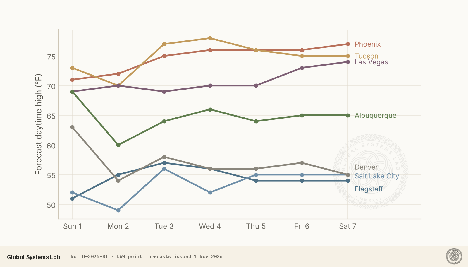
The rain should be short-lived. Forecasters in Phoenix and Tucson expect the moisture to clear by daybreak on Monday, followed by a dry week with temperatures slowly warming, though staying slightly below normal for early November. Phoenix’s forecast highs climb from 71 °F today to 77 °F by Saturday, and Tucson’s to 78 °F by midweek. Las Vegas stays dry and mild, rising from 69 °F to 74 °F.
Behind the storm, the higher country turns cold. Albuquerque drops from 69 °F today to a high of 60 °F on Monday and a low of 32 °F on Monday night, the first freezing night in the forecast. Flagstaff’s nights stay near 30 °F all week. Utah and Colorado are less settled: Salt Lake City has another round of light rain likely from Tuesday night into Wednesday, and Denver, which misses most of today’s rain, has its best chance on Monday and again on Wednesday.
Reading the data
Station reports are point measurements at airports, and conditions can differ sharply over a few miles, especially in mountains and during thunderstorms. A station counted as “reporting rain” had rain, showers, drizzle or thunder in its latest report, not necessarily heavy rain. The forecasts and rainfall totals are those the Weather Service issued around midday on 1 November and will change as the event unfolds; the alert count is a snapshot, and alerts are issued and expire throughout the day. For the latest picture, open the NOAA Weather Map, choose a state or the whole country, and switch the map to dew point to watch the moisture move east.
Sources
- Airport weather station reports (METAR), NOAA Aviation Weather Center
- National Weather Service forecasts and active alerts (api.weather.gov)
- NWS area forecast discussions: Phoenix, Tucson, Albuquerque and Salt Lake City offices, 1 November 2026
Download the data
Cite this
Global Systems Lab (2026). The Southwest's first atmospheric river of the season. Global Systems Lab Transmission D-2026-01. https://globalsystemslab.com/transmission/southwest-atmospheric-river-november-2026
BibTeX
@techreport{lab2026southwest,
  author = {Global Systems Lab},
  title = {The Southwest's first atmospheric river of the season},
  institution = {Global Systems Lab},
  number = {D-2026-01},
  year = {2026},
  month = {nov},
  url = {https://globalsystemslab.com/transmission/southwest-atmospheric-river-november-2026}
}